Best Hikes in Moab Outside of Arches National Park
Ready to find the best hikes in Moab that are outside of Arches National Park?
While it may be tempting to stick to the great hikes inside the national park, Moab, Utah, is an outdoor paradise with miles of trails scattered around the town.
The hikes you’ll find below are easily accessible from downtown Moab, and include a variety of hiking levels so you can pick the perfect one for your skill level and available time.
So, on your next trip to Moab, add on a few more days to discover the incredible hiking trails in this part of Utah!

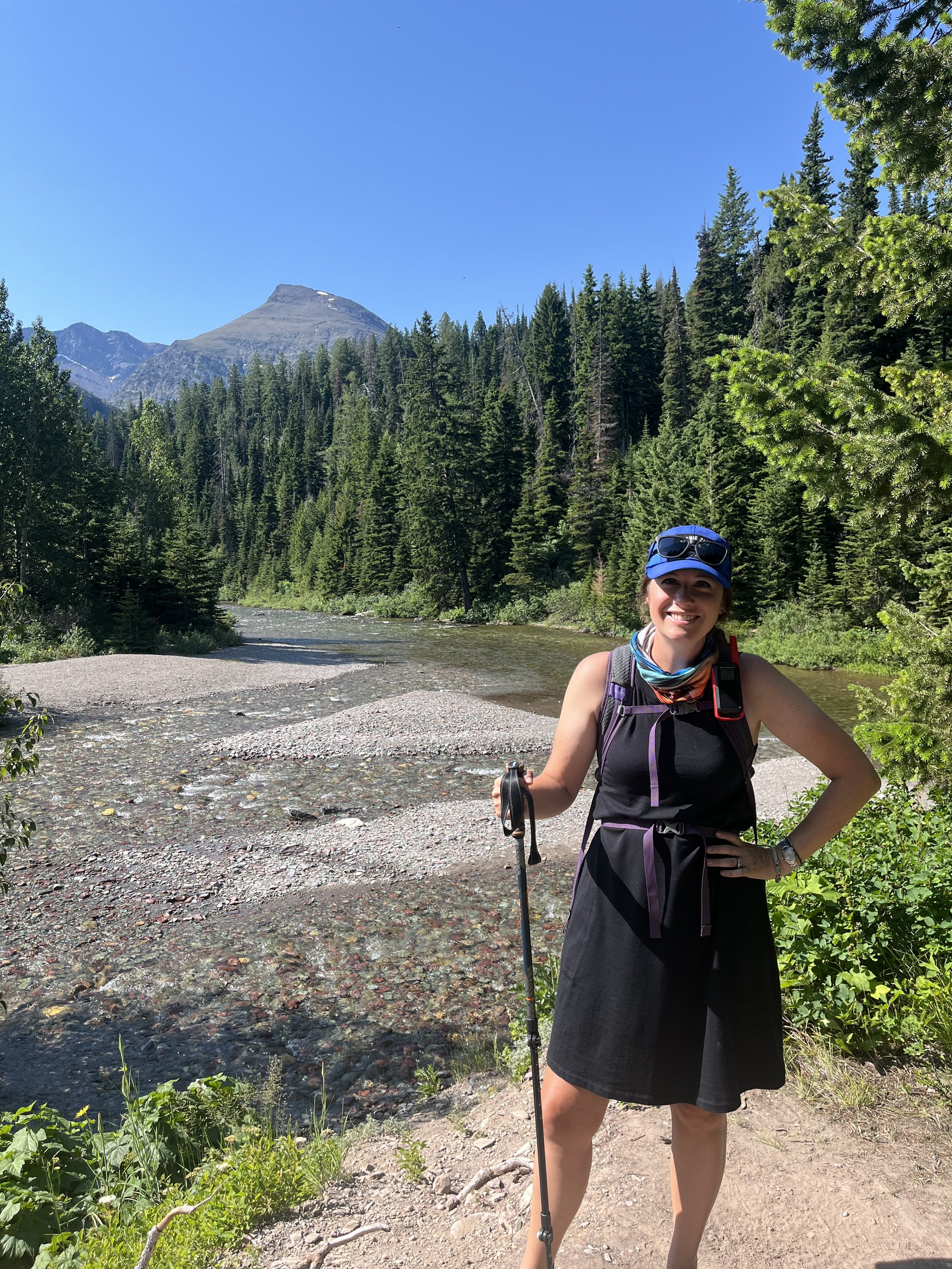
The Camping Kiddos work their way along the Mill Creek hiking trail in Moab, Utah.
This post contains affiliates. If you purchase through the links below, I will receive a commission at no charge to you.
Where are the Best Hikes in Moab outside of the National Parks?
When visiting Moab, it’s tempting to stick to the 2 national parks in the area: Arches National Park and Canyonlands National Park.
Arches National Park is really close to downtown Moab—less than 5 miles—so you might show up there, do a few of the admittedly great hikes and call it a day.
Canyonlands National Park is further out and requires a 30 minute drive from downtown Moab to get to the visitors center.
>> Get a head-to-head comparison of the national parks in our Arches vs. Canyonlands guide! <<
Most visitors to this area focus their attention on these two world-renowned locations since 1) they’re popular, and 2) they’re what Moab is largely known for.
There’s something kind of comforting about hiking in the national parks as these trails tend to be well maintained, well marked, and well traveled. Arches and Canyonlands are 2 of the Mighty 5 national parks in Utah, which are world renowned for their hiking, biking, and incredible landscapes.
Check out my post on visiting the Utah Mighty 5 with kids here, and get even more ideas for your trip!
Why Should You Hike Outside of the National Parks?

PIN ME!
The trails in Arches and Canyonlands are no different.
So, why am I making the argument that you should explore outside of these areas?
The biggest reason is that the national parks in Moab, and especially Arches National Park, can get crowded.
So much so that Arches National Park has had to install a reservation system from April to October in order to regulate the crowds.
Even Canyonlands—which has, so far, resisted a reservation system—can see busy trails and packed parking lots in the peak times.
With all of that going on, you're going to want to escape the crowds and go where the locals hike.
Map of the Best Hikes in Moab
You can see many of the features these parks are known for on the recommended hikes below (i.e. arches and canyons!), but skip the lines, the worry about reservations, and the endless circling the block for a trailhead parking spot.
These non-national park hikes are located on a variety of different properties, including city parks, Bureau of Land Management, and private land (with public access). Since you’ll have to seek them out, you have a greater chance of quiet trails and pristine landscapes sans other hikers.
If you’re a visual learner and want to see how these non-national-parks trails are laid out around Moab, I have a handy map for you below.
You can zoom in and click on the trailhead markers in blue.
Best Hikes in Moab Outside of Arches National Park: An Overview
Corona and Bowtie Arch


At a Glance: Corona and Bowtie Arch
Round-trip distance: 1.8 miles
Rating: easy to moderate
Features: Views of the Colorado River, technical sections, 2 natural arches
Moab is known for its incredible array of natural arches, and the highest concentration of them in the world can be found at Arches National Park.
However, if you want to see one of these incredible arches, there are more ways to do so than getting a timed entrance pass for the national park.
One of my favorite arch trails in Moab is along Potash Road between the entrance of Arches National Park and downtown Moab, and it offers up 2 different arches along the way.
This trail is one of the more popular on this list, but, even so, you won’t find half as many crowds here as you will in the national park.
In fact, most days, you might only pass a couple of other hiking groups along the way.
This trail is generally easy, other than the more strenuous/technical sections towards the end. If you don’t want to do those final sections, you will still get great views of both Corona Arch and Bowtie Arch near the chained climb on the trail.
The trail is an out-and-back hike that’s just under 2 miles round trip.
For more information, check out my complete trail guide to the Corona and Bowtie Arch hike.
Moonflower Canyon
At a Glance: Moonflower Canyon
Round-trip distance: 0.6 miles
Rating: easy
Features: canyon hikes, petroglyphs, small water feature
An easy hike at only 0.6 miles out and back, Moonflower Canyon is an excellent first non-national-park hike in Moab.
It’s located on BLM land, which we’ve found is much less busy than the nearby parks.
The trail offers several items of interest. Near the trailhead, you’ll find several petroglyphs that are much easier to see than the ones you’ll find along Potash Road.
The trail winds down a canyon and ends in a small pool of water, a relative rarity in this part of the world.
The trail to this point is very easy and is suitable for hikers of all ages. It is packed dirt with some rocks, so you can’t bring a stroller, but everyone else should be fine here.
If you want a bit more of a challenge, you can get a better view of the canyon at the end of the trail by climbing the metal ladder that is anchored into the stone. You can access a rock tip from which you’ll get some great overview of the entire area.
During the summer months, your ability to see a full pool will vary depending on how much water the area has gotten recently. You might find a nearly non-existent pool during hot, dry times, or a lush little oasis if it’s rained recently. Either way, I don’t recommend swimming in the water.
Moonflower Canyon, much like the rest of the Moab area, can feel a bit otherworldly thanks to the interesting stone formations in the canyon. However, it’s also the home of some purported supernatural activity; whether you believe any of that or not, it’s fun to recall a few of the Moonflower ghost stories if you have some impressionable young hikers with you.
To access the Moonflower Canyon trailhead, follow Highway 191 through the town of Moab, turning right between the McDonald’s and the Tourism Center onto Kane Creek Boulevard.
The trailhead is about 3.5 miles down Kane Creek Boulevard, and it will be on your left. There is a small dirt parking lot at the trailhead, but it’s not particularly well marked. If you see a large oak tree and a vault toilet in front of a split rail fence, you’re in the right place.
Mill Creek Recreation Area Waterfall Trail
At a Glance: Mill Creek Waterfalls
Round-trip distance: 1.6 miles
Rating: easy to moderate
Features: waterfalls, rock scrambles, swimming hole
A waterfall in a desert climate like Moab’s is unusual.
But this trail offers up THREE!
You can complete the entire 1.6 mile trail, ending up at the final small waterfall and swimming hole.
The entire trail includes a couple of rock scrambles right on the flowing water that were tricky for my 1st grader, so keep that in mind.

The Camping Kiddos at the first of the 3 Mill Creek waterfalls
Or, you can go as little as a quarter-mile to see the first cascade. The first cascade is along a nearly flat path that makes it great for beginning hikers and kids.
This trail comes highly recommended as it is completely unlike any other trail on this list, and my kids love the fact that it includes plenty of places to stop and splash around.
The Mill Creek Recreation Area is popular with locals, and there is a sandy area below the parking lot that serves as a bit of a beach.
To get here, turn off of Main Street onto South Mill Creek Drive. Follow that road until you get to Powerhouse Lane. To follow South Mill Creek Drive, you will need to make a right turn at the intersection of South Mill Creek Drive and Sand Flats Road. The trailhead and parking area are at the end of Powerhouse Lane (part of which is unpaved, but graded and should be passable in all but the wettest weather).
Grandstaff Canyon Trail
At a Glance: Grandstaff Canyon
Round-trip distance: 4 miles
Rating: moderate
Features: streamside hiking, natural arch, canyon hiking
This beautiful trail takes hikers to the Morning Glory Natural Bridge, with plenty of opportunities for splashing in the nearby stream. (If you’re hiking with kids, you KNOW that’s an important feature!)
Start the hike at the trailhead off of Scenic Byway 128, a section of Moab that’s worth a deeper exploration in its own right. In fact, this trailhead is part of an excellent outdoor recreation area near Lions Park, which is listed in more detail further down on this list.
Parking for this trail is available across 128 from the trailhead, but it is limited. At peak times, you might have trouble finding a spot, so keep that in mind.
The trail itself is fairly easy, but it does have a stream crossing and a couple of smaller rock scrambles. I’d recommend wearing hiking sandals (like my favorite Keen Newport H2s) over hiking boots because of the different types of terrain.
You’ll also want to pay close attention to the trail as it has signs, but they’re on the small side. Morning Glory Arch is accessed via the second alcove along the trail from the trailhead—and, depending on the time of year, you may have to battle a couple of stout bushes to push into the canyon.
In any case, trust the signs as the bushes can look like a false ending to that part of the trail.
At the end of the hike, you’ll be rewarded for your efforts with the stunning Morning Glory Natural Bridge. The name is a bit confusing: natural bridges are made from water, while arches are made from wind and other geological forces. Yet, Morning Glory Natural Bridge is an arch as there’s just not enough water in this part of Utah to create a true natural bridge.
NOTE: Head to Capitol Reef National Park and Bryce Canyon National Park to see examples of those!
Regardless of what natural forces created Morning Glory, it’s a sight worth seeing. It’s also the 6th longest natural stone span in the United States, per the Natural Bridge and Arch Society, who probably are well versed in these kinds of things.
While you can continue down the trail through the canyon past Morning Glory Natural Bridge, you won’t find a wow factor like that one any further on this hike.
Mill Canyon Dinosaur Tracksite
At a Glance: Mill Canyon Dinosaur Tracksite
Round-trip distance: 0.25 miles
Rating: easy
Features: sweeping views of high desert, fossilized dinosaur footprints, boardwalk
Was anyone else obsessed with dinosaurs as a kid? (Or was that just me?!)
If you have even a passing interest in dinosaurs or paleontology, the Mill Canyon Dinosaur Tracksite is worth a visit.
Located off of Highway 191—the road that connects I-70 into Moab—the Mill Canyon Dinosaur Tracksite is a short, quarter mile trail that ends in a boardwalk loop. Turn left onto Cotter Mine Road (BLM 215) if you’re on Highway 191 coming from Moab, and continue on the gravel road to the 2nd turnoff on the right.

One of the many fascinating fossil prints and tracks at Mill Canyon
You’ll see a small parking area outlined in rocks. The trailhead for the tracksite hike and loop are at the far left of the parking lot.
In the middle of this loop are more than 200 dinosaur footprints embedded into fossilized rock.
Some of the most fascinating include an imprint of a crocodile slide into what was an ancient lake and a pair of footprints that belong to a huge carnivore that is, as of yet, unidentified.
There are helpful interpretive signs to highlight specific geological information for this site. You’ll also find a covered sitting area halfway around the boardwalk.
This tracksite is located on BLM land near Courthouse Rock Campground. It is free to park and access this area.
It’s a great easy hike for young kids, thanks both to its easy hiking level and the subject level.
Mill Canyon Dinosaur Bone Trail
At a Glance: Mill Canyon Dinosaur Bone Trail
Round-trip distance: 1.0 miles
Rating: easy
Features: Canyon views, embedded fossils
If you need more fossils in your life (and who doesn’t?!), you’ll want to continue down Cotter Mine Road from the Tracksite parking lot until it forks onto Mill Canyon Road.
At the end of this road is the incredible Mill Canyon Dinosaur Bone Trail, one of the most interesting hikes I’ve ever taken.

The Camping Kiddos inspect the rings on a piece of petrified wood at the Mill Canyon Dinosaur Bone Trail.
On this short, 1-mile round trip hike, you’ll follow a narrow path on the side of a hill. In that hill are embedded dozens of fossilized bone fragments, complete leg bones, and even an entire tree trunk.
At the end of the hike, you’ll get some incredible views into Mill Canyon. There’s also a marker indicating the site of the old mill that gave the canyon its name. You can’t see any ruins, but there are large, darkened boulders that are the result of the mine’s operations.
The hike is, overall, pretty easy, but there are a few areas where you’ll need to watch your feet as you climb next to the wall. There are some minor rock scrambles, but nothing that my kids couldn’t handle.
This trail was one of the trails that we took our then-4-year-old to on her first trip to Utah back in the day. She did just fine on it then, and had no issues on our most recent visit when she did this trail again at 10.
Parking here is free. The lot is small, but we’ve never seen another car here while we’ve visited.
Hidden Valley Trail
At a Glance: Hidden Valley Trail
Round-trip distance: 4 miles (with the option to extend)
Rating: moderate
Features: Canyon hiking, long range views of Moab area, petroglyphs (optional add-on)
Ready for a challenge? Take on the Hidden Valley Trail, a 4 mile round trip trail that offers up petroglyphs, isolated canyon views, and some of those incredible Utah stone formations.
The first 3/4ths of a mile or so is rough, as you’ll endue a nearly 700 foot elevation change during that time. If you can make through that section, the rest is relatively flat.
Even with the elevation change, anyone other than the most beginner hikers should be able to do this trail. Just take plenty of water, use sunscreen or a sun shirt, and start early in the day.
There’s an obvious turnaround point at a pinnacle roughly 4 miles into the hike.
One thing that I find fascinating about this trail is that it follows a centuries-old footpath used by the local Native American tribes. You can extend your hike to see some of the petroglyphs, which adds another dimension to this experience.
More information on the Hidden Valley Trail, including details on how to access the petroglyphs, can be found here.
Sovereign Multi-Use Trail at Sun Outdoors Canyonlands Gateway

The La Sal Mountains to the right and the arches of Arches National Park to the left from the trailhead of the Sovereign Multi-Use Trail.
At a Glance: Sovereign Multi-Use Trail
Round-trip distance: variable
Rating: easy to moderate
Features: Long range views of Arches National Park and northern end of Moab
If you want plenty of space to roam without any of the crowds, head behind the old church building at Sun Outdoors Canyonlands Gateway.
There is a small path past the building to a gate, after which you’ll find the start of the trail area.
This entire area is criss-crossed with multi-use trails, so you can hike to your heart’s content. On our first trip to Moab, my husband was training for a marathon later in the year, and he ran many miles out here during our stay at the campground.
You’ll see mountain bikers and ATV enthusiasts on this trail, too.
However, the best thing you’ll be able to see is an incredible view of the arches inside Arches National Park!
It’s technically possible to get into Arches National Park from here, but that would require a nearly 8 mile, one way hike to Balanced Rock via the Willow Springs Trail.
If you’re not up for that long of a hike, you’ll still get great views of the park’s skyline from anywhere along this trail.
The trail itself is hard packed dirt, and it’s largely flat. This makes it a great choice for beginning hikers or families who are new to desert hiking.
Keep in mind that there aren’t any trees or shade of any kind on this trail, so pack a hat and plenty of water.
Lions Park Trail Hub
At a Glance: Lions Park Trail
Round-trip distance: variable
Rating: easy
Features: paved hiking and biking trail, Colorado River crossing
Moab excels at outdoor sports opportunities, and that is obvious in places like Lions Park.
Located on the Moab side of the Colorado River, Lions Park is a great place to start a hiking adventure of any kind.
For those with young kids or who don’t want a big commitment, you can span the Colorado on the pedestrian-only Colorado River Bridge.
This bridge is a part of the Moab Canyon Pathway, which connects more than 8 miles of paved multi-use pathway from Lions Park to above the entrance to Arches National Park.
You can also hike alongside the Colorado River from Lions Park via the multi-use path that runs alongside Scenic Byway 128. This path connects with the Goose Island Trail, offering miles of potential hiking. If you go far enough, you’ll run into the trailhead for Grandstaff Canyon (above)!
If you’re traveling with small kids and want a trail that is great for strollers, look no further than the Lions Park Trail Hub. You can walk to your heart’s content during your little one’s nap as the trail is both scenic and great for strollers.